
Part 2, July 9-13
Once we had all disembarked our cruise ship, the American Spirit, we spent a bit of the morning wandering around Juneau, stopping for breakfast, and then heading for the airport; our friends flying to Portland, Oregon and we flying to Anchorage, Alaska. We stayed overnight in Anchorage and then drove north about four and a half hours to our lodging at Denali Village, a few miles from the entrance to Denali National Park and Preserve.
Private cars are, for the most part, not allowed to drive more than about 15 miles into this three million acre wilderness park (done in an effort to absolutely minimize traffic and maintain its amazing wilderness quality). One of the few ways to see the park is to take
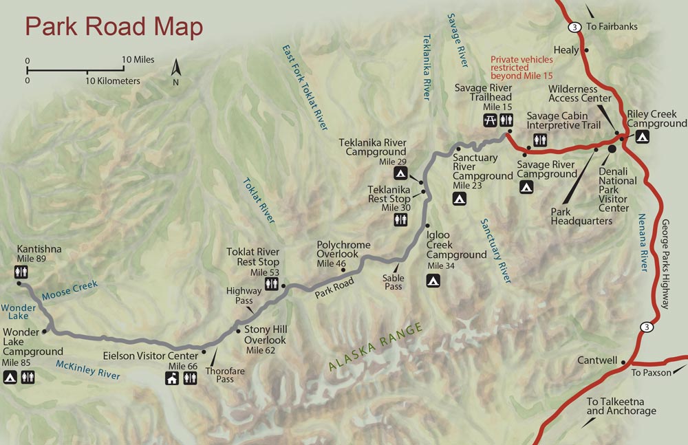
a bus tour that crosses it using the only developed road available. We signed up for the eight hour tour which covers about two thirds of the road.

One of our first (pit) stops was along the Savage River. There are a couple of things to notice from the photo on the right. One is that the sky is very overcast. Apparently, this is the more-often-than-not state of the sky during the brief summer season. We were told that it is highly unlikely that we would actually get to see Denali (the actual mountain) because of the constant clouds. You will see other examples of of the state of the sky in photos posted in the Alaska gallery of my photography site.
The other thing you should notice is that this part of the park is actually well forested. That is another difference that is obvious when you see that much of the park visible from the road tour is Alaskan tundra (defined by Wikipedia as “a type of biome where the tree growth is hindered by low temperatures and short growing seasons”).
As it turns out, much of this tour is also about spotting wildlife. We did see, and photograph, caribou (AKA reindeer) and grizzly bear. We also saw some interesting birds and some Doll Sheep (too far away to look like much more than tiny white shapes on the mountain-side). The birds we saw were too fast for me to catch a decent shot but my wife captured a great image of a Willow ptarmigan (the Alaskan State Bird) which is also posted on my photo website (with permission of the photographer and due credit, of course).
 During our return we were stopped briefly by some road construction/repair and I noticed that what had been a solid overcast all day was breaking up into defined clouds (it was after 10 PM by this time and there was the beginning of a sunset). I managed to get a decent sunset shot before we returned to the bus to complete the tour (getting back to our cabin close to midnight when it was actually starting to become dark).
The next day we wandered around a bit to explore the area, visited the park’s Visitor Center, and drove out into the park again (limited to even less than 15 miles because of an issue with a bear near the end of the unrestricted portion of the road). The sky was much clearer with broken clouds (what our local TV weather-person would call “partly clearing”).

After a local dinner/show (a humorous take on some early Alaskan and Denali history) we spent some evening time packing for an early departure the next morning. Our schedule was such that we needed to drive the four and a half hours back to Anchorage, drop the car, try to grab an afternoon meal, and catch a multi-plane flight to Portland to rejoin our friends.
The day we left Denali Village the sky was incredibly clear and we enjoyed wonderful views on our way back to Anchorage. At about the halfway point of the drive we noticed that we could actually see a southern view of Denali (the actual mountain) from the highway. We pulled off and took a few minutes to capture some (apparently rare opportunity) images of the mountain and parts of the Alaska Range of which it is a part.
 Denali actually has two peaks, appropriately named, North Peak and South Peak. In our photos you can see both of them. The South Peak, on the left in this southern view, is the highest at 20, 320 feet while its shorter sibling is only 19,470 feet. We particularly enjoyed that the river just visible in the foreground of these images is called Lower Troublesome Creek (which, correctly, implies that there is also an Upper Troublesome Creek). We could not find out the origin of the name (but it’s fun to imagine various scenarios of what it might be).
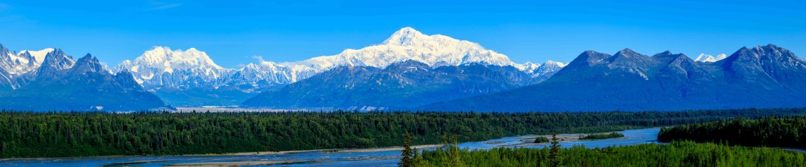
Just to finish off this post (and because I’m proud to have caught Denali on a rare visible day), I’ve added this stitched-together 14-image panoramic of the same scene to show how much Denali towers over other mountains in the Alaska Range. Other images of Alaska can be seen on my photo website by clicking on this link. Or you can get there by going to Ced Bennett Photography and clicking on Places, selecting United States, clicking on Alaska, and then clicking on any of the thumbnail photos on that page (to see the images larger and not as just cropped, square thumbnails.

1 Comment