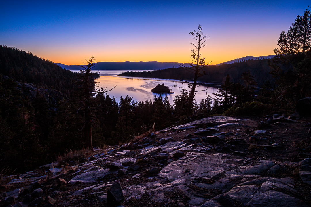
I just love this view. But, again, no clouds that morning so I decided to emphasize the sunrise starting to light up the rocky foreground in this image by using a much wider focal length than I would normally apply (24mm, 1.6s, f/16, ISO 200)
Readers of this blog know that we spent a week at Lake Tahoe in mid-August — and will now understand that we came back up in mid-September for another, slightly longer, stay. The weather during our August stay was uniformly quite warm and mostly cloudless. Approaching autumn in mid-September, the weather seemed more variable and getting cooler, especially at night. The day we arrived, it was sunny, fairly warm, and beautiful. The wind direction then changed overnight and when we woke the next morning, the entire region was covered in smoke coming mostly from the large Mosquito fire (burning about 50-plus miles west in both El Dorado and Placer Counties). Another night passed and the wind direction changed again and over the next two days that smoke disappeared (from the Lake region).
Why talk about the weather so much? Well, we’d come up again with a couple of goals in mind. One of mine was to take a few more photos. For Billie it was a chance to focus more on some complex knitting projects. For both of us, it was also a time to relax, away from home where time seems to be filled with all those every-day tasks that cannot be ignored, and instead just enjoy the beauty of the mountains and the lake.
So, when the smoke cleared and I could see the sky filling with some clouds I figured I’d go out the next day to try and get some photos with more interesting skies. Except, for the next three days, it rained quite a bit, and even snowed sometimes in the higher elevations around us (8,000 feet and higher). That was fine for Billie since both her goals of relaxation and knitting would normally be done indoors anyway. For me, the relaxation goal was certainly handled but I didn’t want to head out into rain without a buddy (in case I was injured hiking and climbing on wet rocks). Then, on the last couple of days of our stay the rain ended and I did manage to go out twice. While waiting for the smoke to clear and the rain to stop, and in between relaxing, I decided to start working on another tutorial blog post I had been thinking about for a while (which I did complete and post after we got back home — Getting Everything in Focus – A Photography Tutorial).
With just two mornings to get some shots, I decided that I wanted to try again for some images from the eastern shoreline (Nevada side) of the lake and I also wanted to go back to the area above Emerald Bay (California side). I had found a different place to try out in Nevada; a place called Chimney Beach. I decided to head up there first, again using the new app that would help me find the trail and keep me on track (the only disadvantage, again, was that it would start with a downhill hike). The serious plus was that there was a good sized parking lot at the trailhead (although that early in the morning there was only one other vehicle there).
The trail was a bit indirect (I think to make the uphill return a little easier) so when I reached the shoreline, I was a bit south of the beach. Happily, for me, I found a couple of compositions looking south (away from the beach) that I liked (that included some clouds and even a hint of the snow that was still visible on some of the mountain peaks on the California side).
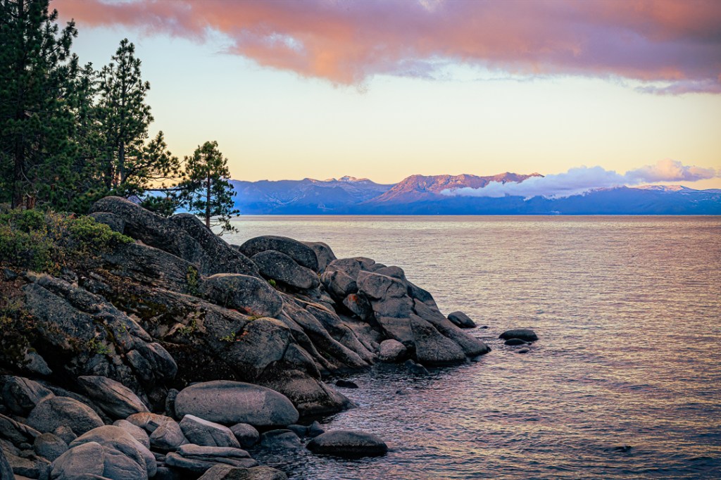
Sunrise along the Chimney Beach Trail with a bit of snow showing on the peaks across the lake (58mm, 1/40s, f/16, ISO 800) 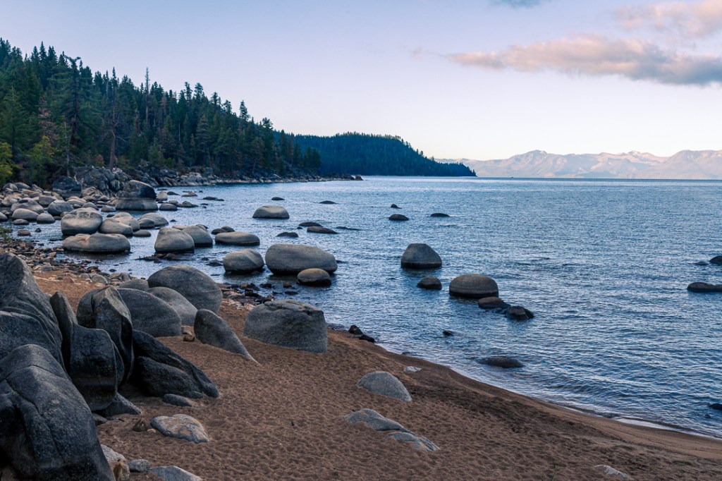
Getting closer to Chimney Beach (40mm, 1/60s, f/16, ISO 800) 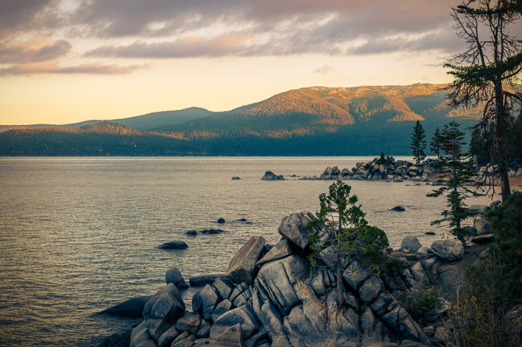
Sunrise along the North Shore mountains and another tree seemingly growing out of granite (67mm, 1/80s, f/16, ISO 800) 
Intrepid swimmers braving cold water at Chimney Beach (67mm, 1/400s, f/16, ISO 800)
About the time I’d taken the first of these four photos, I heard some noise on the trail and turned to see four young women hiking down the path and moving fast toward Chimney Beach. I didn’t realize that at least one or two of them were actually planning to swim in the little cove there. In the fourth photo above, you can just see two of the non-swimmers (one standing on a rock on the beach and another leaning against the first large boulder to the left of the other woman). A third person can be partly seen between the V-shape formed by two boulders and she seems to be in a bathing suit). Also, a pile of clothing is on a flat rock further to the right of the rightmost standing women. At the size of these blog images, it is difficult to see all the detail in them. If you are curious, you can go to directly to this particular photo in my Flickr 2022 Album1 and click on it a couple of times to zoom it large enough to examine closely. Or not, of course.
Also, on a different topic, I admit that I imagined that the name of the beach was referring to some natural rock formation that someone had dubbed as a ‘chimney’ (I’ve seen many such formations with that name elsewhere). I never walked over to stand on the beach to check it out or look for it, but when I was processing the third photo in the slideshow above, I noticed an actual stone chimney and fireplace right on the beach (partially obscured in the photo by tree branches). Apparently, it is the only remains of a caretaker’s cottage that was once on this beach. If you want to take a closer look at that photo, just click this Chimney link and it will take you to that image in my Flickr 2022 Album.
At this point, I’d been there for a while, looking for compositions and shooting some and decided it was time to hike out and head back to South Lake Tahoe to meet Billie for breakfast. Having been in the mountains for almost a week, I was a bit more acclimatized to the altitude so the hike was not as difficult as a similar one in August (not easy — just not as difficult).
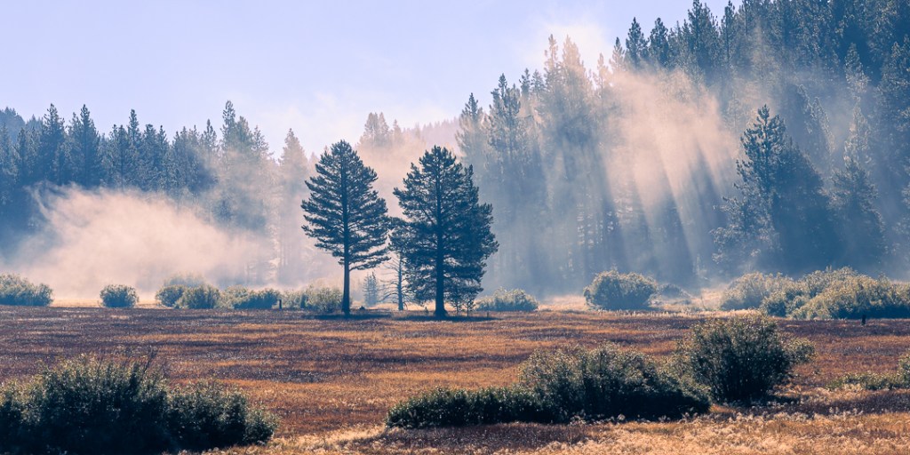
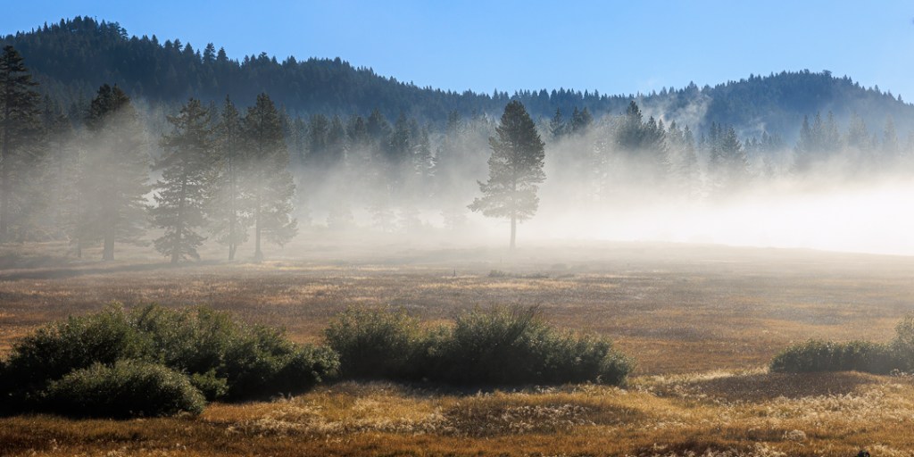
I got back on Nevada highway 28 and headed south. I was a few miles away from the junction with US 50 in Nevada (which would take me the rest of the way back into South Shore) when I noticed a local fog phenomena and stopped to watch it and to grab a couple of images of it. I was particularly taken by the shadow pattern created in the fog by the sun shining through trees in the image on the left. I’m no meteorologist but it seemed to me that this fog was being created by the sun evaporating large amounts of water (from the three days of rain) rapidly enough to form this fog. It was in constant motion and did seem to be rising. Note that you can click these two images directly in the post to see them significantly larger.
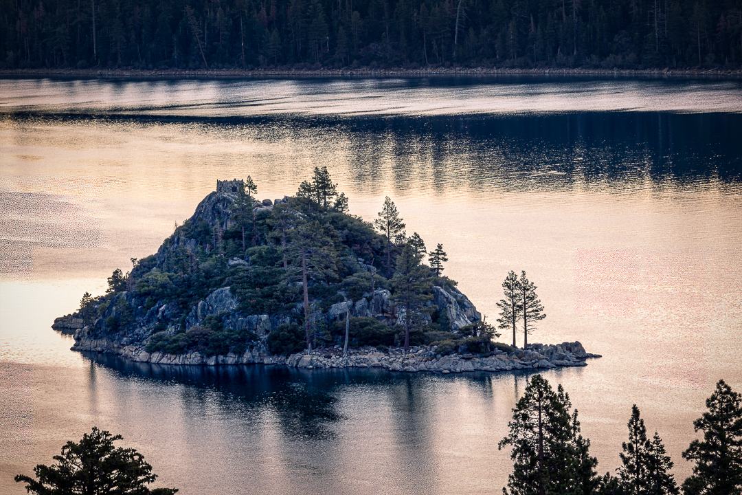
The following morning, and my last opportunity on this trip to go out for another photography trip, I drove over to the area above Emerald Bay (and took the shot shown at the top of this post). Aside from that sweeping landscape shot, with the sky again empty of clouds, I switched to a longer lens and focused directly on Fannette Island, in Emerald Bay. You can see the square outline of the remains of the Tea House at the very top of the island.
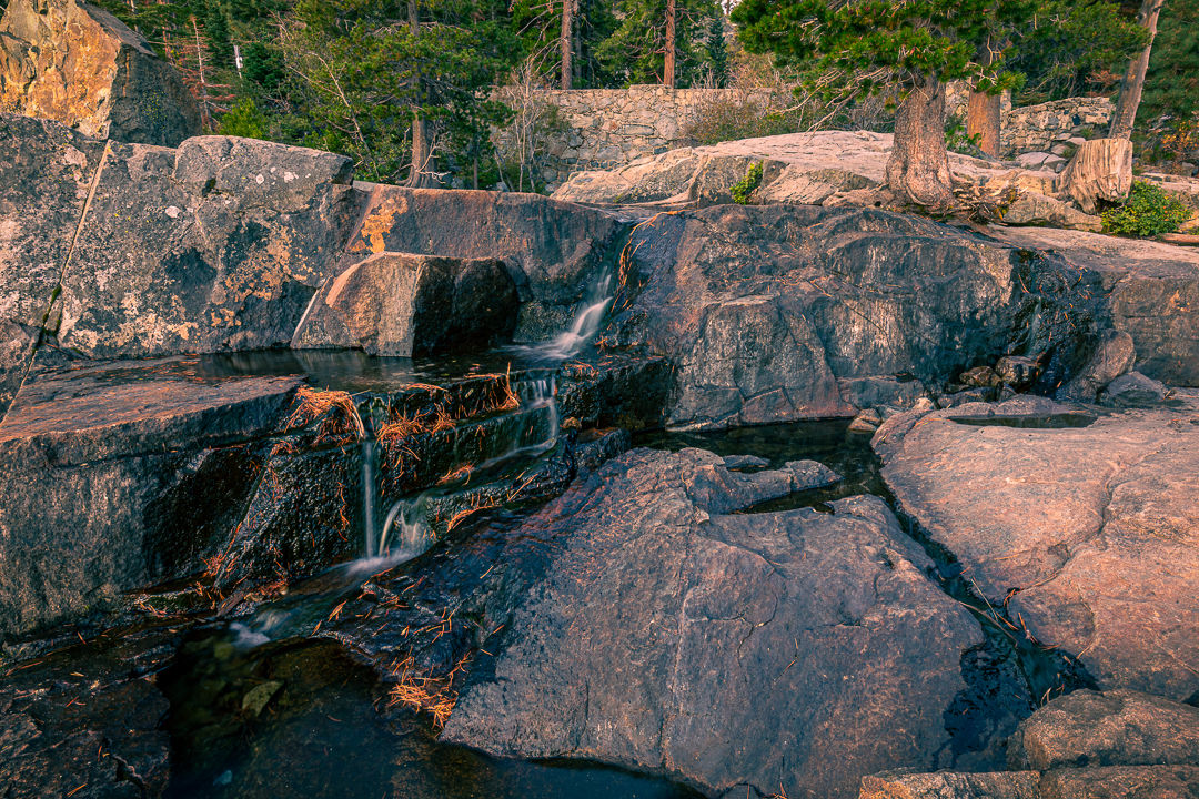
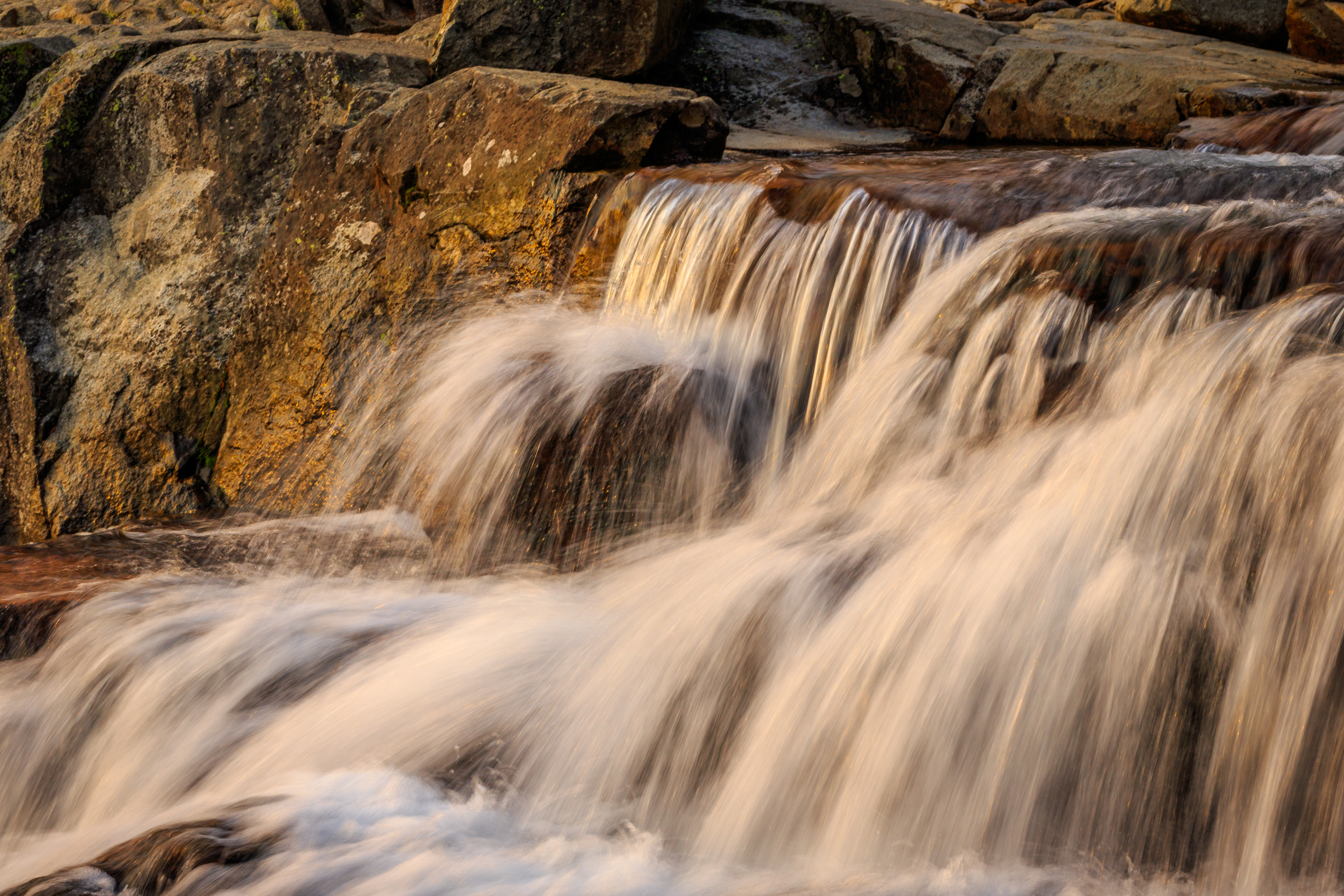
I had noticed, when writing my previous post, Return to Lake Tahoe, that when I was lamenting the effect of the drought on the level of Eagle Falls, I did not really have a recent good comparison image of the falls today vs the falls from several years ago. So, I figured, while I was here again, I’d try to get one. And I did. There is not much to say about it that the photos below don’t already convey.
All in all, we considered this another successful visit. I managed to get some additional photos and Billie made significant progress on her complex knitting project. That afternoon and evening, we took care of most of our packing and went out for a very nice dinner. The next morning we were on the road headed home.
Thank you for reading all the way to the end. I hope you enjoyed some of these views of Lake Tahoe. If you’ve got questions or comments, you can use the reply section near the bottom of this post.
Footnotes
1 Only some of the images in this post (or any post on this blog) are in my CedBennett.Photography website but all of the photos in the blog post are also posted to my Flickr website and are typically saved in albums by year and also in sequence of most recent to oldest (so all the photos in this post are in my 2022 Album there). If you are a regular visitor to my CedBennett.Photography website I always recommend that you first click on the What’s New menu item. Everything there is presented in newest to oldest sequence so that’s the place to check out my most recent additions.
By the way, I recently made a change to the organization of my photography website; all the Lake Tahoe images have been moved out of the Places > United States > North Eastern California menu item and into a new section; Places > United States > Lake Tahoe Area [CA & NV].
2 You probably won’t find the term “[lower] Eagle Falls” on maps (at least, none that I’ve seen). I invented it because if you check a map yourself, you will likely find a designation for Eagle Falls to the west of highway 89 above Emerald Bay, and you may find another designation for Eagle Falls to the east of the highway also above Emerald Bay. They are both in the same creek fairly widely separated from each other but still in the same water channel. I use the term, [lower] Eagle Falls to refer to the waterfall that is east of the highway, to avoid any confusion for folks who might spend time sightseeing or hiking in the area.

2 Comments